Travel review INDIA 
A trek in the past
Delhi, Manali, Jispi, Palamo, Jankarsumdo, Chuminakpo, Lakong, Kargiakh, Phuktal, Pipula, Reru, Padum, Pishu, Hanumil, Snertze, Lingshad, Marlin, Photaksar, Honupatta, Wanlah, Lamayuru
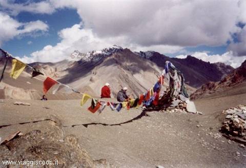 Prinkti-La pass
|
Pagine 1
|
  
A trek in the past
Località: Delhi, Manali, Jispi, Palamo, Jankarsumdo, Chuminakpo, Lakong, Kargiakh, Phuktal, Pipula, Reru, Padum, Pishu, Hanumil, Snertze, Lingshad, Marlin, Photaksar, Honupatta, Wanlah, LamayuruRegione: Ladakh Stato: INDIA (IN) Get out from Delhi and look at taxis and buses waiting. I have immediately the impression of having made a leap back in time Fifties. Entering in Zanskar the jump in the past becomes even of 1000 years. A genuine return to the Middle Ages. The region of Zanskar, which corresponds to the namesake river basin, extends at southeast of Leh and is a desert and isolated location with fabulous landscapes of immensity and hardness, where the ancient Tibetan traditions are continuing. The population lives of autonomous economy because of the altitude and isolation caused by the lack of connections, blocked by heavy snow on access roads. True to its origins and insensitive to the passage of time, the Zanskar continues to live its archaic biological rhythms. To breathe the religion of heights is not necessary to have mystical predispositions. In the villages placed along the trails and peaks of Zanskar, the religion is a constant presence and the reference to the divine is evident everywhere. It is recalled by the festoons of pray entrusted to the wind at every height, by the banners and the monasteries golden signs, by the chortens and the engraved votive stones at every turn of the path, by the countless monks and by the sacredness of the same mountains. And the walk into the bright light of the 5000 metres of height also becomes a pilgrimage at the shrine of the oldest faith in the world: the Buddhism.
The trekking in Zanskar revealed me three fundamental components: nature, adventure and culture. I must say that none of this three disappointed my expectations, that, indeed, have been largely overcame.
The description of the natural component is simple: 19 days of walking through unspoilt nature, surrounded by mountains exceeding 6000 metres in height. Following the course of rivers and impetuous crossing passes that sometimes were located over 5000 metres. It was the first time we visited these places and the experience proved to be stunning. The color of mountains is fascinating: red copper with nuances tending to green. The reminiscent color for the Dolomites. Wonderful bushes of flowers that grow behind the boulders, even on the higher passes. Fantastic was the starry firmament which we could observe in clear sky nights. I personally do not remember having ever seen a sky so starred like the one in Zanskar.
The adventure component: the word adventure comes from the Latin "ad venturam", that means entrusted to chance. So adventure is everything not programmed to the smallest details, even unexpected. For us adventure was represented by the two days trip of bus from Delhi to Darcha on narrow roads, often dirt and built upon precipices. Roads that could also be interrupted by landslides. Adventure was experienced during the trek in the many fords crossed barefoot. Adventure was represented even by the meetings with the residents of several villages encountered on our journey. Certainly it was a minor adventure compared to journeys made by Bonatti, but in my opinion equally amply rewarding. The cultural component was certainly the most interesting. We had the great luck to host with our group Gianfranco (a professor of History of Religions at university) which for several years attended these places to find out meanings from the various signs of Tibetan culture. In the visits to various monasteries, Gianfranco was a very useful source of informations and explanations. The many represented figures hadn't secrets for him and now also for me. The strongest emotion that I felt entering a monastery is like if time stopped hundreds of years ago. There is a tranquility and a peace that Westerners like us forgotten or perhaps better have never known.
from Delhi To Manali
At 6:30, with about an hour of delay, we land at Delhi. Took baggage and pased customs formalities we leave the airport. Here we wait for the van to start immediately the two days of travel that still separate us from Darcha, the beginning of our trek. Crossed the outskirts of Delhi in the midst of a chaotic traffic and accompanied by very annoying warm and humidity. Soon we meet the first signs of poverty that will accompany us throughout all our journey, that in this case is represented by endless tent camps placed at the edges of the road, where the poors live. Just outside the city the weather improves and there's sun. The journey is long and tiring. Finally, after midnight, we reach Manali and hurriedly set at an hotel.
from Manali to Jispi
Manali is a charming tourist town at 2000 metres of altitude in the Kullu Valley. It is surrounded by green woods of conifers. In its center you can find shops and markets where you can go for shopping and meet people. I spend the morning walking in the centre that was full of people. Patrizia and Beppe are buying other food that, in addition to those brought from Italy, will be eaten during the trek: sacks of potatoes, rice and various vegetables are added to spaghetti, tuna, cheese, meat, jam, honey and biscuits. A supply of food sufficient to cover the programmed 19 days of trekking ahead of us. The weather is beautiful with a warm sun. At 13:00 we resume our bus and head to Jispi. The road in some places is breathtaking: not paved, narrow riding on high overhangings. After 3h of travel we stop at Rothang Pass (3980mt) after 51 kms of road, where we stay for a brief pause. Unfortunately there is a fog that hides us landscape and the temperature is low. Again on the road we descend in Lahaul Valley. Here landscape changes drastically as the green mountains that characterized the Kullu Valley are replaced by bare mountains. We are running in the middle of tiny villages surrounded by fields of barley and potatoes on the road that goes along the river Bhaga. In the village of Khoksar, after 20 kms, there is a military checkpoint. On this occasion we eat something at a typical restaurant. At 21:00 we set in a shelter in Jispi, about 6 kms from Darcha, where we'll spend the last night under a proper roof. Tomorrow we finally begin to walk. The night is beautiful and the sky is covered with stars.
from Jispi to Palamo
In the morning we know our chef-guide, Hary, and other 4 horsemen that, along with 15 horses for the transport of food and baggage, will accompany us throughout the trek. They seem very young. They have no luggage and the only things that they have are only those worn: light trousers, a t-shirt, a fleece, a k-way. Some of them wear rubber boots, others sports shoes and one of them simply a pair of slippers. I stop to reflect thinking at my bulky luggage that they have to load. The weather is beautiful with a warm sun and a smooth sky. Patrizia, our coordinator, gathers us saying: "Boys, at wish the van can lead us up to Darcha. The other groups started to walk from here. What are we going to do?". Not really aware of the several miles of difficult walk awaiting us the answer was unanimous: "We'll start from here!!!". I don't know if us all were convinced or if none of us wanted to show signs of weakness. Surely we could save those 6 kms of gravel road continually travelled by columns of military vehicles and civilian trucks, which passage raised annoying clouds of dust. However even this is part of the adventure. While horsemen load horses, we move slowly on foot, and after just over an hour we finally arrive in Darcha, point of departure of Zanskar trek. Darcha is a small village, situated at 3400 metres of altitude, consisting in some houses (built as the majority of homes here in Ladakhe stones held together by clay, dung and white lime) and small shops arranged under military parachute-tents, where you can find a bit of everything. Also here is one of the many military control stations. Once arrived our horsemen and once agreed with them the next stage, we can finally leave for the trek, at 11:00 o'clock. The trail start climbing for 100mts, behind the shops at the side of the road, and goes back to the left bank of the river above. We move between meadows of grass, where we find women intent to harvest it. Then we walk on a road under construction until reached the village of Rare, at about 12:30. We decide to stop Here for lunch under the trees. It is very hot as the sun is high (T= 27°C). We restart at 13:00. Shortly after we cross a second village, Cikak. A little further we find a suspension bridge made with logs of wood, where an impetuous river runs under (beautiful canyon). We pass on the right bank of the river. At this point there are several fords to cross. At 15:00 we arrive in Palamo. The stage is short and simple, but it is better to climb slowly at high altitudes for a better acclimatization. The campsite is in beautiful lawn with a stream flowing in the middle and there is a parachute tent as house. Once set the camp we walk around waiting for dinner. Angela, our daughter of flowers, taken away by the hot day cahnges even to swimsuit and makes bathing in the river... after all she originally chose a journey of sea and changed in a trip of trek at high altitudes later. The evening is beautiful with a starry sky at night. We can see a bright milky way (T= 12°C).
from Jankarsumdo to Chuminakpo
Wake up at 7:30 (T= 8°C), breakfast and then depart at 9:00. The sky is veiled by some cloud. We immediately cross the suspended the bridge consisting of wooden beams and stones, held together by a wire mesh (the most challenging of the trek). The horses have shown some reluctance on crossing this bridge and three of them refuse it categorically. So they are unloaded from the luggage, which is transported manually, and are finally able to wade. The current is very strong and impetuous, but luckily they managed to touch the opposite shore. From this point the trail begins to rise significantly for 150 meters, then, along the right bank of the river, we match some slopes to come down again. The road is in gravel. At 12:30 we stop for lunch. During the day the weather worsens and the sky is completely covered with threatening clouds. During the path we cross two streams. At 14:30 we arrive at our 3rd field: Chuminakpo. It's the highest camp set throughout the whole trek. The camping is good enough: grassy false plans with many rocks and hard ground, the source and the river are neighbouring. Unfortunately we are surrounded by a dense fog and we can't see the surrounding landscape. In the early evening a violent storm unleashes on us forcing a retreat in our tents (T= 11°C).
from Chuminakpo to Lakong
At 4:00 stops to rain. We get up to 6:30 (T = 7°C), have breakfast and then start at 8:00 heading to the mythical pass. The landscape is still surrounded by a dense fog. After 1h of walk we arrive at camp Ramjak (small and stony). The trail climbs gently for about 400mts, then for the last 100mts becomes more demanding. Shortly before crossing, begins to fall a disturbing light drizzle. Along the trail we don't find snow, but we walk on slippery and irregular rocks. At 12:00 we are at Shingo La pass (5.090mts - T= 3°C), reported by the classic prayer flags. Brief stop with traditional group photo and then long descent slipping on various snow patches and wading some streams. We entered in the Zanskar valley. We walk along the river between expanses of grass, flowers and edelweiss. At 15:00 we arrive to Lakong camp. The site is discreet and located in a large valley: grassland with many stones, a source and a river are in the vicinity, and there is the tea house. Luckily the rain stopped and we can prepare tents with calm. We try to dry our stuff, but it is totally unnecessary, there is high humidity. We are very tired and we finish dinner soon to withdraw quickly into our tents (T= 9°C). At midnight another violent storm unleashes on us.
from Lakong to Kargiakh
At 3:00 stops to rain. We wake up at 6:30 (T= 6°C), have breakfast and then start to walk at 8:00. The clouds lifted up and the various peaks that surround us are now full of fresh snow. Even the road walked on the first day is covered in white. If today we had to overcome the Shingo pass, we certainly would met the snow, but luckily we have passed it already. We overcome (suffering) a wooden bridge and then wade different streams. We walk along the Kargiakh river valley riding on his right bank. The trail is beautiful and easy, developing in a false floor. It is also full of blue, pink and yellow flowers and the mountains begin to show the typical colors of Zanskar: purple and green. We walk under a disturbing drizzle that alternates moments of calm. Shortly before the Kargiakh village we meet various Mani walls and chortens (very suggestive) that give us welcome in Zanskar! At 14:00 we are at the village, crossing it, in a tea house we find an hyperbaric chamber (incredibly). Inside there is a Nepalese that feels bad because of the altitude. The camp is 1/2h of walk from the village. The camping is good: beautiful grassy meadow near the river and a source. After placing tents, along with Beppe and the girls of the group we make a visit to the country. We find many young children and women: men with older children are in high pastures with yaks. People are very hospitable and offer us their food and the traditional Tibetan tea. Returning to the camp we have dinner and then go to bed (T= 10°C). In the evening restarts to rain.
Purne - Phuktal -Purne
Today we don't dismantle the camp but we will make a deviation from the main route in order to visit the monastery of Phuktal. We left horses in Purne to follow the path that starts just above the camping, along the river Tsarap. The road runs in a splendid gorge. The trail is a stone field and in some places there is danger of landslides. After about 1½ hour of walk we arrive to a small tributary of the Tsarap with a magnificent waterfall. We cross a bridge and, with a small climb of about 15 minutes, we reach a plateau with a chorten. The road abruptly turns left and Phuktal appears as a breathtaking vision: a long row of Mani walls and chortens leading to the monastery perched on a rocky wall, under a natural grotto in a fantastic position. It looks like a beehive. In the cave there is a well where the water level remains constant, even if they use a considerable quantity. This water is famous for its therapeutic properties. In the monastery there is also a table of stone left by Alexander Cosma de Koros, a Hungarian who visited Tibet and lived here in 1826-27. The Phuktal Monastery is one of the most spectacular of Zanskar. Phuktal belongs to the tradition of Gelupas (monks with yellow cap) and about 70 people live here. In the late afternoon unleashes another storm. We refuge in the kitchen-tent... hoping that it would hold on. Dinner and then sleep (T= 11°C). Many of us suffer flu-like symptoms: cough, cold and sore throat.
From Purne to Pipula
Towards morning stops to rain. At awakening a bitter surprise awaits us: 5 horses escaped and our horsemen are looking for them. Patrizia does not trust to leave and remains at Purne until they found them. The day is beautiful and the sky is smooth. Only at 12:30 we can get on the road. We return on the path to Jal and cross again the wooden bridge taking then the right-turning path. The road is a dusty stone field that lies halfway along the left shore of the Tsarap river. In many places there is high danger of landslide. We cross various villages: Cha, Kaydang and Hamuni. In the latter we stop for 1/2 an hour in an equipped shop. It's very warm. The landscape is charming. Shortly after the shop there is a steep descent leading to a steep climb. The road continues along the river at the bottom, inside a canyon. At 18:00 we arrive in Pipula camp. The camping is ugly, small and narrow. The ground is hard and full of stones and we are located very close to the river (the noise is deafening). There is a small source and a shop. We decide to place here although it is very ugly, but unfortunately it's too late to continue and the next camping is Ichar, which is about 1:30h of walk far from here. We have dinner and then everyone to bed (T= 13°C). This will be the first clear night after several days.
from Pipula to Reru
Wake up at 6:30 (T= 11°C), breakfast and then start at 8:00. The time is uncertain as the sky is veiled by some cloud. We come back to our path until reached a bridge of wood and iron, after 1:15h of walk. Passed it we visit the village of Dorzog. The small group of houses is very distinctive, particularly the prayer hall and the various chortens. We restart at 10:30 following the path on the right bank of the Tsarap river, and after 45 minutes we arrive at the fortress village of Ichar. Our visit here is accompanied by countless children. At 12:00 we are walking again, crossing fields of barley remaining high upon the river below, always on the right shore. The road is panoramic and spectacular. Once at the confluence of another river, in the distance we can see the green lawns of Reru. The trail drops significantly and then, after crossing a new wooden bridge, climbs up again for other 200mts. The camping remains behind the village in an elevated position. At 15:00 we arrive to our camp. The camping is great: a beautiful lawn with a pond in the middle (to note that in the morning the water level rises), a source and stream nearby; quiet place. The temperature is pleasant and a beautiful sun warms us. I take this opportunity to dry my clothes and wash them. Angela accuses a strong pain in the knees, the day after we will continue on horseback. We have dinner under a spectacular starry sky (T= 13°C).
from Reru to Padum
We wake up at 6:30 (T= 11°C), have breakfast and then start at 7:45. The weather is beautiful with a warm sun. After about 45 minutes we arrive at the monastery of Mune. We are successful in attending the morning function. At 9.30 we walk on a dirt road under construction. There's a lot of dust and the day is humid even the road is monotonous. After about 2h of walk we arrive to the Bardan monastery, situated above a small hill on a bend of the river. Bardan is located 12 kms far from Padum. Here we stop for lunch. At 13:00 we start to walk again and after 2h we finally reach Padum. The path is flat. Once in the city we take part to a general drunk to celebrate the end of the first part of the trek. Padum is the capital of Zanskar, rather ugly, but situated on a magnificent plateau, on the shore of Zanskar river at a height of 3650 metres. It is linked by a road to Kargil, Leh and Srinagar. There are numerous hotels and restaurants, a post office, the public telephone post and numerous shops. In this cold and inhospitable plateau live simple people whose only livelihood is represented by barley and peas, the only crops that grow to this height. Their only wealth is given by flocks of sheeps and goats in addition to the famous Zanskar horses. With the exception of Padum, where 40% of the population is Muslim, the inhabitants of this plateau are Buddhists. We set the field at about 1 km of road from Kargil, we visit the town and buy the necessary for the continuation of trekking. The situation is calmt and we haven't seen tensions, troop movements, or anything strange. Angela decided to continue alone, taking the bus to Leh. The bus leaves from Padum at 17:00 and arrives at Kargil towards midnight. The next morning we go again to Leh, where we arrive in the late afternoon (always depending from the conditions of the road). All together we eat some local delicacies, like the classic momo (very good) in the kitchen-tent. In the evening comes a shining starry sky (14°C).
from Padum to Pishu
We find a truck that brings us up to Karsha village, located on the opposite shore of Zanskar and connected to Padum by a dirt road, saving approximately 2 hours of monotonous journey. The sun shines high and the sky is cobalt blue. The monastery overlooking the village offers a magnificent view of the wide valley of Padum, surrounded by spectacular mountains. We can admire two impressive peaks: Nun and Kun, respectively 7135 and 7076 metres. At 10:30 we put along the sandy and dusty trail. The surrounding landscape is very beautiful, but wild. The stage of today, more than a trek across the Himalayana chain, looks like a crossing of the desert. We walk on a paths without any tree and the only shadow that we find is that of some big boulder. The sun is burning and the temperature certainly exceeds 30°C. After 2 hours of walk we arrive in Rinam, where we meet 2 tea houses. We stop here for lunch. We restart on the left side along the Zanskar river. After 2 hours we reach the village of Pishu. We walk through the alleys and, passed the last home, we find a beautiful green field: our goal. The camping is great: a beautiful lawn with source and river nearby and there is a tea house. Given the beautiful day we decide to do laundry and general cleanings, then to relax. The evening is beautiful with a magnificent starry sky (17 ° C).
from Pishu to Hanumil
The day is beautiful with a warm sun and smooth sky. The trail is easy with continuous up and down along the Zanskar river. After 2 hours of walk we cross the village of Pidmo. Along the route we stop several times to drink. We arrive in Hanumil at 13:00. Pass not so difficult with beautiful landscapes. Maybe the only little difficult is represented by a rather long walk made barefoot on a ford full of pointed stones, shortly before the camp. From tomorrow we'll begin to climb again. The field is great: beautiful grass lawn covered with edelweiss and surrounded by willows, there is the tea house, a river and a source in the neighbourings. In the afternoon we walk around and then generally relax. The evening is beautiful and warm (T= 20°C).
from Hanumil to Snertze
We continue to follow the Zanskar river on the left shore, with continual slopes for about 1,3 hours. From this point the valley tightens increasingly and our path begins to rise at the Purfi La pass (3.900mts). The last 300 meters are steep, but also made easy by a narrow serpentine. We arrive to the pass in 3h. then we stop to admire the landscape. At 11:00 we resume the journey along a dizzying descent (half way there is a pipe for water), where we lose altitude quickly (500m). After 45 minutes we arrive at a bridge over the Oma-Chu river and we pause for a brief stop under the shade of beautiful trees. It is very warm. From this point the trail goes back steeply. The road is dusty and exposed with impressive overhangs, especially the last stretch overlooking a canyon of which we even cannot see the bottom. An hard climb of 400 meters in 1 hour. Arrived to the top we enter in the huge valley of Hanuma, reached with a comfortable path, which falls to the river, leading to a camping site placed between two huts of clay and some terraces for tents. We arrive in Snertze at 13:30. The camping is ugly: gravel with many stones, there is the tea house, and a beautiful river with a source in the vicinity. We all decide to swim in the river. The evening is warm (T= 20°C).
from Snertze to Lingshad
We start at 7:00. The trail makes some left/right turns along the river for about 400 meters, we walk it in 1h. We cross a bridge made of ice, then our path becomes less arduous and the road is increasingly narrow in the valley. We even see some ibex. After 2h we find a building used as tea house. We arrive at Hanuma La (4700 mts) at 10:30; development: 900 meters in 3,3h. We stop to eat something. From here we can enjoy a magnificent view on the beautiful Lingshad valley. In the distance the monastery and the village with its green terraces are visible. Everything is surrounded by Dolomite peaks with incredible colors. It's one of the most beautiful landscapes I have seen during this journey. The sun is veiled by some clouds, but warm. At 12:00 we start to walk along the steep descent that leads to the river; 1000 meters in 45 minutes. Wefollow the river for 10 minutes, then take a path that climbs over a ridge on our right side. The stage is very lively: climb and descend for other 2,3h. We arrive to the camping site at 15:30, after crossing the village of Lingshad. The camp is ugly: gravel and rocks everywhere, nearby there is a small source and a well stocked tea house. But it is located next to the monastery and from here we can enjoy a splendid view upon the village. The evening is clear with a beautiful starry sky (T= 18°C).
from Lingshad to Marlin
In the early morning we visit the monastery. It is very beautiful and we arrive while the monks are eating and meditating in the prayer hall. They offer us tea and zampa. At 8:30 we follow the path behind the camp. it starts climbing decidedly until 2 chortens. Arrived at this point we walk on a long beam and then again the path is steep until Margum La pass (4100mts), 1h of walk. From this pass we can clearly see the path that we must cross: a marked zig zag path that climbs up on the golden mountain in front of us. The day is beautiful and humid. We cross a steep and dusty descent until reached a watercourse, in a total of 1h. Then we cross two villages: Gongma and Skiumpata. From this point the trail climbs up rapidly of 500 meters in 1h. We arrive then in Kuba La pass (3.800mts) at 12:30 where we stop for lunch. After lunch we proceed to the general clearing of Marlin, 45 minutes of walk. We set our camp on a splendid balcony surrounded by a frame of pastel colors. The site is discreet: gravel with stones, there are a stream and a source and nearby and the usual tea house. In the evening the sky becomes cloudy and at 21:00 begins to rain, lasting for about an hour (T= 18°C).
from Marlin to Photaksar
The sky is covered by clouds and we are surrounded by a dense fog. After 45 minutes we arrive at camp Gagio (ugly and small). From this point the trail begins to climb steadily. Only the last 100 meters are tough, but also made easier by a narrow serpentine. In 1,3 h we arrive to the Singe La pass (5060mts). The fog has gone, but the sky is always covered. In front of us opens a large valley surrounded by mountains with glaciers on their top. We leave behind us the basin of Zanskar to enter that of Yapola, a direct tributary of Indo river. We stop for 1h. As usual a steep descent awaits us, about 1000 meters in altitude. Then we'll continue on a false floor along the river until we find some demanding fords, 1,3h of walk. Crossed these watercourses the trail begins to rise again until arrived to Boumitse La pass (4200mts), but the ascent is easy. We are on pass at 14:00. In the valley below we see different marmots running between lairs. The path goes, descending, on a ridge on the left side of the river and then continues along false floors with some small streams to cross. After 30 minutes we are at Photoksar camp. The place is great: beautiful lawn with a torrent and source nearby. It islocated on a beautiful balcony overlooking the village, at the edge of a ravine surrounded by spectacular mountains of pastel color. At our shoulders enthrones a stunning mountain with a glacieron its top. Unfortunately at 16:00 a violent storm unleashes, lasting for about 1 hour. At the end magically appear two magnificent rainbows. In the evening the sky clears, leaving the scene to a beautiful starry sky (T= 18°C).
from Photaksar to Honupatta
The day is beautiful with a beautiful sun. The trail continues to fall for another 200 meters and goes through some streams. We cross fields of barley and meet many people at work. The village of Photaksar is wonderful, perched on a small plateau above a precipice. After about 1h we arrive to a bridge over the river, we cross it, and at this point the road begins to rise. Shortly after we meet a chorten where the path turns decidedly at right, with a slight climb before and with a narrow serpentine then until Sirsi La pass(4.850mts). Once at the top a breathtaking spectacle awaits us: a large valley formed by countless pinnacles of golden sand opens before us. We stop, being really exstatic, to admire the landscape for one hour and half. Our trail is now formed by stones and drops dramatically for about 700 meters. We see many marmots: fat with dark fur. There are various streams to wade and we even meet a new wooden bridge. We arrive at 13:30 to the first campsite of Honupatta (there are several campings here), but it is ugly, small and full of stones. We see a beautiful green lawn below us near the river and, after a long discussion with our horsemen, we convince them to follow us. In the afternoon we walk around, dive into the river and relax. The evening is beautiful and warm (T= 20°C) and a magnificent silver moon illuminates the river and the valley.
from Honupatta to Wanlah
Once again all our horses escaped. We decide not to wait until their discovery, because the stage of today will be very long. After 15 minutes of walk we are able to see, on the other side of the river, the main camping of Honupatta: overcrowded with people and tents. A little after we meet the first houses ofn the village. There are countless hotels, restaurants and shops. Fortunately we decided to make our first stop before this point. The sun is veiled by some clouds, but very warm. The trail goes along the river on the left side, down below. We meet several caravans of people and horses directed to Lingshad. Beautiful gorges appear in the landscape before us, distinctive and evocative for colors, with different shades of purple and green, and different rock formations. The trail is recent, often carved on the living rock overlooking the river. The road is a continuous up and down. We meet a bridge built recently, but not to cross, so we continue behind the rock proceeding on the left bank of the river. We leave the gorges reluctantly because we must abandon the magnificent and almost unreal landscape that characterizes this place. The valley is expanding rapidly and also our path becomes a big mule track. From this point we walk on a road under construction until reached the village of Phanijla. Very beautiful, with its fields of barley and numerous mature apricot trees. People are intent to harvest. We decide to stop and wait for our horsemen. Fortunately they arrive at 15:00 to continue the journey. The landscape has changed: all around us there are trees and green or yellow fields. Also along the road under construction we reach Wanlah after 1,3h. The village is great and there are many tourists. The monastery is perched on a ridge above the village. The camping is ugly: gravel with different stones. We agree with the owner to camp in a beautiful green lawn just cut. In the vicinity there is the river and a small source. Unfortunately, the trek is over and relaxing and quiet evenings are finished. However during our last evening we are able to see a bright milky way (T= 20°C).
from Wanlah to Lamayuru
This is the last leg of our trek. Before getting on the road we are going to visit the monastery. Unfortunately, we find it in a state of semi abandonment, dilapidated and even with a single monk. At 8:15 we start marching towards the final step only to be tackled before reaching our goal: Lamayuru. The trail continues upon the river, on the right bank, behind the camp. After 1/2h we encounter a core of houses and a bridge, we cross it carrying on the left bank of the river. A little further we find a chorten and several mani walls. We turn sharply rightwards entering in a canyon. The narrow gorge is squalid and we can't see anything; quite monotonous. The last 150 meters are harder and follow the path with several left/right turns. At 10:15 we arrive at Prinkiti La pass (3.725mts). The view is magnificent: a spectacular valley with golden mountains. We descent rapidly on the bed of a dry creek. Then we meet a chorten and, turning our gaze to the left, finally Lamayuru appears us in all its splendor, magically perched above a hill. The oldest monastery of Ladakh lies before us, after having covered about 340 kms on foot. The surrounding landscape is wonderful: green willows, mature fields of barley, and red and yellow mountains. The campsite is located above the village, near the main road. We decide to place for the last time our tents, so we find a field near the Dekung Labrong Restaurant. Here we also find that Angela welcoming us with kisses and hugs. In the afternoon we visit the monastery. The walls are frescoed with scenes that inspire serenity and peace alternated with paintings depicting bloody dragons and demons. The day is beautiful with a slight breeze and a cobalt blue sky. We have dinner at the restaurant with beer at will to celebrate our glorious enterprise.
We have completed the trek that is certainly the most interesting part of our journey. We have still a week to pass here, before returning to Italy. Finally we reach, with a journey of 6 hours on a truck load of potatoes sacks, the capital of Ladakh: Leh. Here we pause to rest from the tiring four days of trekking. We pass this period visiting the beautiful town and some monasteries in the vicinity (Rizong, Alchi, Likir, Hemis, Matho and Tikse). Leh is situated on a plateau formed by the Green Indus River at 3500 meters of height. It is a small town with narrow intersecting streets, and a main road that leads to the old palace of Rajah Laddak, built in 1553. An ancient king has a built 108 chortens in this place, all lined in a row (the number 108, which is also the number of volumes composing the Buddhist Bible, is sacred to the Hindu and Buddhist religion each). On 18th of August we are coming back to Italy. The connections between subsequent flights allow us to visit Delhi and then Amman, the capital of Jordan. Reflection: It is not easy to translate into words the experiences done and especially the countless emotions felt during this trip. Certainly I had the impression that it was among the last witnesses of a culture and a world that is destined to disappear. In Tibet, after the invasion of China, the Tibetan culture has almost disappeared. Only the remote regions of the Mustang and Dolpo in Nepal and the Zanskar valley in Ladakh have been able to preserve their ancient traditions. I think that tourists contribute, albeit unintentionally, to change the way of life of these populations. My view should not be interpreted as an invitation to not visit these places, but I suggest them only for people that know them well (maybe the only way to love them either). It has to be intended as an invitation to visit them in "tiptoe". In order not to exhibit an easy "welfare" against persons who always lived, and are still living, with the little resources that nature offers. Even the difficult climatic conditions contribute to the nearly total isolation of the inhabitants. Children, for example, attend schools only in the summer months, because during the long winter the entire population is forced to live closed at home. Very rare are also contacts between the inhabitants of near villages because of the difficulty on roads and distances. The rivers and the streams, which we crossed, in the winter months are completely frozen and are used as "roads" by the inhabitants, to shorten the distance between villages. Another very interesting aspect of this trip was the pilgrimage between different monasteries. In ancient times these were used only as a refuge for travelling monks during the rainy season. They later became stable homes. It is impressive to note how many items that in the western we consider only waste (such as empty cans, old shoes and many other), are instead recovered and jealously considered an asset by those who live in these places. To conclude these reflections about my trip, I suggest that all those who wish to move closer to places so unique and unspoiled, like these, must not behave like tourists, but as lovers of adventure always respectful of every reality encountered, trying their best to adapt to the way of life of these peoples. Behaving in this manner we certainly won't arrest the end of this culture, but we'll probably contribute to slow down its extinction. Zanskar Trek sheet: The total kms to walk are 340, and there are 9 passes to overcome. The first part of the trek, from the point of view of landscape was in the first stages monotonous. But from a religious perspective, is the best and most interesting. The second part of the trek is the most known and for this reasons even the most attended. The various symbols of Tibetan religion are neglected. Surely it is the most beautiful road to travel from the mountaineering point of view: magnificent sceneries with breathtaking mountains and canyons. The path is well set and widely recognizable, there is no possibility of getting lost. The main difficulties of this trek are: the height and the countless fords to cross. Overall this trek was very nice and absolutely not dangerous, if weather conditions are similar to those encountered by us. Otherwise the area (being a desert at high altitude, where most of the trail is exposed) could be affected by landslides. Our times have always been pretty relaxed, quiet walks that made possible to look around, take photos, enjoy the beautiful landscapes. In general any stage was probative from the physical point of view.
|
|