Travel review ARGENTINA 
Patagonia, an endless horizon
Peninsula Valdez, Punta Tombo, El Calafate, Lake Argentino, Perito Moreno, Fitzroy, Cerro Torre, Upsala, Puerto Natales, Cuernos del Paine, Torres del Paine, Puerto Natales, Ushuaia, Buenos Aires
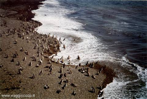 Penguins at Punta Tombo
|
Pagine 1
|
  
Patagonia, an endless horizon
Località: Peninsula Valdez, Punta Tombo, El Calafate, Lake Argentino, Perito Moreno, Fitzroy, Cerro Torre, Upsala, Puerto Natales, Cuernos del Paine, Torres del Paine, Puerto Natales, Ushuaia, Buenos AiresRegione: Patagonia Stato: ARGENTINA (AR) "... Recalling images of the past, I discover that the plains of Patagonia are back with insistence to my eyes, yet those plains are seen by all bleak and unnecessary. They can be described only by negative characters; without homes, without trees, without mountains, producing only a few dwarf plants.
Why then, and this does not happen only to me, these arid deserts have impressed me so strongly in the memory?
Why haven't pampas produced an equal impression, more flat, more green, more fertile and useful to mankind?
I could not analyse these sentiments, but they must depend partly from free rein given to the imagination.
The plains of Patagonia are boundless, because they are viable with difficult, and therefore unknown; everything suggests that they remained unchanged for millennia and that they will remain like now for a long time ... "
Charles Darwin, a naturalist journey around the world.
Thinking back to my travel on the plains of Patagonia, aboard regular buses on dirt roads, I can not fail to evoke emotions and memories similar to those described by Darwin in his story of the relationship had with these places in 1834, during his trip around the world made from 1831 to 1836, on board of the Beagle ship commanded by Captain Robert Fitzroy. Reminders of immense spaces beaten by the winds grow where only thorny shrubs rare, with poor lines of communication and a few remote villages distant hundreds of kilometres between them, but so inhospitable and wild places produce an irresistible charm in who, like me, tries to avoid the traditional tourism destinations. Patagonia, however, is a country of sharp contrasts and thus to landscapes so little hospitable, alongside lakes and blue rivers, green forests, snowy mountains and glaciers pushing their fronts in the waters of large lakes. Strong disagreements arise even in climatic conditions and management of territory: in a few hours you can move from hot summer to intense cold with strong winds, often accompanied by snowfall. Great differences can also be found in human settlements: a few kilometers away from residential areas, highly exploited by tourists, lie completely desert areas where human presence is, when not totally absent, so sparse and well integrated into the environment to represent also part of the natural landscape. Maybe this place just gives everyone the opportunity to visit places of indescribable beauty and charm, and then link them with roads and tourist exploitation in full compliance; but I can not ignore how fascinating it would have been when admired in all its original wild splendor, as it looked when Alberto Maria De Agostini watched it, in the first half of 1900, during the exploration of these lands.
Discovered by Magellan in 1520, Patagonia hosted stable settlements of Spanish and Welsh only by the second half of '800. The current region, in the cartography of the sixteenth century, was indicated by the name of "Land gigantum", the name derives from the impression that generate from the first meeting between natives and Magellan and Pigafetta that, in their travel reports, called the locals "Patagonians" for the imprints left by their footwear ("Patagones" literally means "bigfeet"). Referring to reports left by travelers and explorers, we recognize two communities of population: the northern one (at north of the Strait of Magellan), and the southern one (Tehuelche, Ona) settled in the land of fire.
The night sky, which in the Southern Hemisphere is plenty of stars instead of what we are normally accustomed to admire, is wonderful, and the Ursa Minor constellation, which includes the Polar star that always indicates the north, is here replaced by the group of stars forming the Southern Cross, which clearly indicates the south; Pigafetta in its report wrote during Magellan voyage around the world called it "a wonderful cross"; Dante also mentions it in the Purgatory of the "Divine Comedy" ( 1st chant, verses 22-24): "... puosi mente/ a l'altro polo, e vidi quattro stelle/ non viste mai fuor ch' a la prima gente ..." ("...And here, near the other pole, I could see four stars, never seen by anyone that wasn't God...").
Even the kitchen of Patagonia, with its speciality, deserves to be cited. The best recipes are meat based (especially from sheeps and goats) obtained from the slaughter of animals left free to graze in the huge "estancias". The Asado is the most typical receipt of Argentina and in particular of Patagonia: practically the entire animal prepared, stuck on a cross of iron planted in the ground near a wood fire, left to cook for hours. The Parrillada is another typical way of cooking meat in Patagonia: it resembles a common barbecue but, together with cuts commonly used in Europe, they put some unknown or even despised on our behaviour as offal, kidneys, intestine and others. More typical of Patagonia is the Empanada, made with small pieces of meat and vegetables enclosed in a strip of dough that can be cooked, baked or fried. Among the desserts, should certainly be mentioned the Dulce de Leche, which you can obtain by cooking at low heat milk and sugar, and has a taste similar to our candy mou. The typical drink is the Mate, similar to the tea, with decidedly bitter taste.
Arrival in Patagonia
Finally, after an interminable travel from Italy to Buenos Aires, with a subsequent internal flight, we land in the late morning at Trelew, in the province of Chubut, northern Patagonia. Here a van awaits us, with it we are going along the 60 kms route that separates us from Puerto Madryn, our first goal and input port for excursions to the Peninsula Valdes. Puerto Madryn is a town of 83.000 inhabitants that overlooks the Gulf Nuevo, surrounded by hills behind which forms a natural amphitheatre. The free afternoon allows us to make a walk on the beach to visit the settlements of the first Welsh immigrants, who settled in the area at the end of 1700.
The Peninsula Valdez
Day dedicated to visit the Peninsula Valdés and to admire the many colonies of penguins, sea lions and elephants that lie in its shores. The Península Valdés, named in honor of Antonio Valdes, Spanish Minister of navy in the second half of 1700, shows an unusual form, linked to the continent by the Ameghin isthmus, a strip of land 35 kms long, which separates the Gulf of San Jose, in the north, from the Gulf Nuevo, in the south. Through a bus we are carried out in almost the entire peninsula contour: we visit the Caleta Valdés, a long inlet separate from the ocean by a thin strip of land 32 kms long, where a large number of birds and marine mammals are concentrated; Punta Norte, at the north-eastern tip of the peninsula, with numerous colonies of sea elephants, observed only by a pitch from the promontory; Puerto Pirámides, the only town on the peninsula (70 inhabitants), located on the Gulf Nuevo, which hosts in its vicinity a colony of "lobo marino de un pelo", a mammal belonging to the order of Pinnipeds and Otarids vulgarly called sea lion; finally Isla de los Pájaros, an island visible from the shores of Ameghin isthmus, elected natural reserve in 1967 to protect the wide variety of seabirds that here live and breed.
Punta Tombo
Another day dedicated to tourism and to visit Punta Tombo in which lives the largest colony of Magellanic penguins existing in Patagonia (about 500.000 animals). The wildlife reserve at Punta Tombo is situated on a beautiful promontory that overlooks the Atlantic ocean; penguins that populate this area eat mainly fish. But they go up to 3 km inland to nest, so this entails an uninterrupted movement of these cute birds from the sea to their nests and vice versa. From the crowded beaches you can clearly notice a trail of penguins in continuous movement, which, with their characteristic undulating step, move in both directions. As the area is highly tourist and visited by thousands of people, penguins are accustomed to human presence and don't show any fear when they meet people in their continuous walkaround. Indeed, an intruder on their way not wanting to deviate from the chosen path, is becoming persuaded to move by them with beak hits! I took some ritual photos, before starting at 13:00 to return to Puerto Madryn with a detour towards the village of Gaiman (9000 inhabitants) to visit the old colonial buildings made of stone of the first Welsh settlers that founded it in 1874. Gaiman, whose name derives from the araucan and literally means "sharp stone", is located 15 kms from Trelew, along the Rio Chubut, near water sources useful to irrigate fields. In perfect Welsh style are also the several "tea houses" where, in the afternoon, in an atmosphere from the nineteenth century, you can taste the sweet drink accompanied by delicious, home made sweets.
El Calafate and Lake Argentino
Day of transfer, with 2 hours flight from Trelew to Rio Gallegos, 49000 inhabitants, located on the banks of the homonymous river and capital of the Argentina province of Santa Cruz. With subsequent 4 hours travel by bus on a dirt road, we arrive at the village of El Calafate, the second destination of our journey and base for excursions to the Parque Nacional Los Glaciares. El Calafate is a tourist town of 1700 inhabitants on the shores of Lake Argentino, at the foot of Cuesta de Miguens, that takes its name, as the river that crosses it, from a symbolic bush of Patagonia; already among the first settlers and travellers of '800 circulates a legend about the fruit of Calafate bush: "Those who tasted the bittersweet berries of Calafate already feel attracted and conquered by the spirit of Patagonia, and when he will have lips dirtened of its bluish juice, he will fail to forget this land and will always feel an intense sense of nostalgy that will push him to return". Personally, I think I have yet eaten so many of these fruits, which appearance is quite similar to blueberries that grow on our Alps. Already by the end of '700 several shipments, going up the Santa Cruz river, came to Lake Argentino, but being convinced to have reached Lake Viedma, placed a few kilometres further northwards. Only in 1877 Pascasio Francisco Moreno arrived on the shores of that lake, during an in-depth exploration of the area, having confirmation that river Santa Cruz came not from Lake Viedma but from another large lake, and baptized it with beautiful sentences produced by his artistic vein: "Internal Sea, son of that motherland mantle that covers the cordillera, into the immense loneliness, the nature which created you has not gave you a name: the human will, from today, will call you Lake Argentino".
The Perito Moreno Glacier
Day dedicated to the visit of the Perito Moreno glacier. The glacier is located between the Brazo Rico and the Canal de los Témpanos, both branches of Lake Argentino. The Perito Moreno glacier, which falls like a huge river of ice from the Cordillera, shows the traveler all the splendor and charm of his face, 5 kms long and 60 meters high. Front that is all notched and full of giant seracs, much to resemble a Gothic cathedral; from it huge blocks of ice break and fall into the lake, causing a huge noise and giant waves. The Moreno, unlike most other glaciers, is in continuous progress and in December 1939 came to block, for the first time, the Canal de los Témpanos, linking up with the peninsula of Magallanes, and then blocking the drainage of Brazo Rico; then waters began to grow, until the water level passed of about 9 meters that of the lake, reaching such a force to destroy the dam of ice previously formed. This phenomenon was cyclical repeated every 3 - 4 years until 1988, attracting tourists from all over the world to watch the great event. Unfortunately, after 1988, the phenomenon has not occurred anymore, the causes are likely to be sought in temperature growth linked to the hood of ozone depletion.
Towards the Fitz Roy
Finally today we start to walk. Departure at 7.30 by bus to El Chalten, base camp for climbing to Fitz Roy, Cerro Torre and point of departure for our first trek. At 13.30 we match the path, starting decidedly uphill in a beautiful forest of beech trees, that leads us in 3 hours to the Poicenot field, at south. After 1 hour of walk, reached a plateau, begins to snow; small and sparse snow flakes are coming down, immediately forming a white mantle that creates wonderful contrast with the green of grass and trees, even the temperature drops significantly and the sky covers up: a pity, because from the plateau where we are the top of Mount Fitz Roy could be admired in the distance. Just above the junction for the Capri lagoon, the trail climbs again for a short stretch, then continues with evolutions more or less flat until we reach the base at 16:30. We set tents in a forest that shelters us from the snow, meanwhile decreased in intensity. The temperature remains fairly rigid, about 2°C. The fast dinner eaten at 19:00 under the snow, fortunately, doesn't affect our morale that remains very high.. Despite the cold we laugh and joke joyfully. At 20:30 the temperature drops to 0°C; so we decide to withdraw in tents to sleep with the intention, if the weather eventually improves, to wake up at 4:00 in order to arrive at dawn and admire the first rays of sun above Mount Fitz Roy.
Fitz Roy
I wake up at 4:00 and go out from the tent. It snows. I wake Cristina to agree whether to start or wait until better weather. We decide to sleep yet an hour; back into the tent and I fall aslept again, when I wake up it's 6:00. It doesn't snow more, but the whole area is whitened by fresh snow, the temperature is a few degrees below zero. General awake to get to the mirador of Fitz Roy, leaving camp at 7:00. We don't dismantle tents, they will be recovered at return for the second part of the stage that must lead us near the Cerro Torre. From the field we cross the Rio Blanco in order to reach, after a brief climb, the clearing that hosts the base camp for climbings to Fitz Roy. While we follow the path, a steep climb, leading to Laguna de Los Tres, resumes to snow; rising up the landscape increasingly whitened gets more charm and beauty. At 8:45 we reach the mirador, it doesn't snow anymore, but the Fitz Roy can't be discovered, you can only admire the basis and a section of wall of Cerro Poicenot. We are at a low altitude, about 1100 meters, but the landscape is typical of high mountain with rocks covered by snow and, over the lagoon placed just below us, the glacier leading to the attack of the Fitz Roy wall; temperature is maintained on 0°C. For many years it was believed that the Fitz Roy, (Chaltén is the original name for the Tehuelche indigenous), was a volcano. Also Pascasio Francisco Moreno thought it when, in 1876, saw the mountain for the first time, deceived by clouds exchanged for smoke, which always crown its peak. He also owes its current name. The explorer describes it this way: "... In a moment of clear, we are able to see between dense clouds the black cone of the volcano and a slight column of smoke that rises from its crater. Tehuelche repeatedly appointed me with superstitious terror about this mountain that smokes. It's the Chaltén that vomits smoke and ash and makes the earth tremble; it provides stay to an infinity of spirits, which trouble the bowels of the mountains. As this mountain was mentioned neither by sailors nor from travellers, and since the natives call it Chalten, a name which is also used for other mountains, I would name it Fitz Roy volcano, as a sign of gratitude that Argentines gave to the memory of wise and vigorous English admiral, who gave to geographical science the discovery of Austral coasts". In early afternoon, around 13:00, we start to the De Agostini field, located near the Torre lake, 200 metres below the previous year. The weather remains unstable, doesn't snow, but sometimes a disturbing rain accompanies us. At 17:00 we come to the camp, protected and placed under the trees. During the night rains and can be heard the noise of a strong wind.
the Cerro Torre
Throughout the night continues to rain and the wind shows no signs of stop; fortunately the field is set in a sheltered position. There is no point in getting up early with a better weather, so we sleep up to 7:30. At 8:30 we start under a light rain with the intent to reach the mirador of Cerro Torre. In a few minutes we'll run up to the front moraine of the glacier, which currently closes the lagoon downstream Torre, once reached the top, the route continues on the crest formed by moraine lining the lagoon. From this point the sight, if the visual condition would permit, view would range onto Cerro Torre that lies before us, immediately after the lagoon; unfortunately clouds surround him and impede the view; on the ridge where we are blows a wind of such a force that we struggle to remain standing up, sometimes we need to cling to a boulder or lie down on the ground to avoid being dragged away. We remain a few minutes on the site, knowing that the Cerro Torre is there, a few hundred metres from us, without being able to admire it; considering dangerous to continue with such this wind, we descend to the field, disappointed of not being able to enjoy the view of most famous mountain across Patagonia. The famous Austrian mountaineer Heinz Zak, met at De Agostini field together with a climbing companion, tells us to have been in this place for three weeks, waiting for the right time to explore a new route on Cerro Torre. He said also that in this period he has not been able to admire it more than 5 or 6 times, and only for 5 minutes; this partly consoles us. At 13:00, once dismantled the camp, we return to El Chalten where the 18:00 bus awaits us for the way back to El Calafate. During the descent time changes to fine and shows on our right a beautiful mountain, Cerro Solo (2121 metres) which, as its name indicates, stands isolated from all others. The Fitz Roy is left to admire in the distance, we also take some pictures: it's sad to think that yesterday we were at its feet and we failed to see it! Only Cerro Torre, in his superb majesty, refuses to our view. During the 4 hours of bus that separate us from El Calafate we admire the patagonica plain, the immense and boundless spaces, and the same people that attracted the attention and interest of Darwin.
The Upsala Glacier
Day dedicated to the visit of the Upsala glacier. Departure at 7:30 with bus for Punta Banderas, located on the shores of Lake Argentino, at west of El Calafate. From there with a boat at 9:00, we will head to the north of the lake until reaching Baia Cristina after 2,5 hours of navigation. The weather, unlike the past days, is very beautiful, and the crossing, carried out between floating icebergs, gives us a magnificent view on mountains and glaciers surrounding the lake. At 11:45 we start on foot for a trek of about 2,5 hours that will lead us to Upsala glacier. During the walk we can see on our right, the Cerro Norte (about 2700 meters) that, with the complicity of a clear sky without clouds, shows in all his splendour the terminal glacier. Suddenly appears, in a breathtaking vision, the glacier: perhaps the biggest of the whole Southern American mountain range, an area of 595 km², that extends for about 60 kms from Cerro Don Bosco to the Upsala arm of Lake Argentino. It presents his 6Kms long front, with an height variable from 60 to 80 metres. It is fed by several smaller glaciers, forming a total basin of about 1000 km². It owes its name to the homonymous Swedish city, whose university sponsored, in early '900, the first iceological studies in the region. In 1952 the glacier was crossed for the first time in an expedition led by Colonel Emiliano Huerta and engineer Mario Bertone. The eye sweeps on chains of snowy mountains that surround it and, with my mind, I would be able to stop the time to enjoy endlessly so much beauty, but unfortunately the boat awaits us at 17:00 at Cristina Bay for the return.
Puerto Natales - Chile
Today we abandon Argentina to move in the Chilean Patagonia. Departure by bus at 7:30 heading to Puerto Natales where we will come at 13:30. Puerto Natales, 16000 inhabitants, capital of the Chilean province of Last Esperanza, is located on the banks of Last Esperanza creek, communicating with the Pacific Ocean. In the afternoon we make shopping and a visit to the country which is very nice, but with an architecture devoid of imagination, like the majority of the towns in Patagonia with the typical urban tradition of Spanish "cuadra", where all roads intersect at 90 degrees. The weather is cloudy but not cold; thinking of the 6 days of trekking that wait us from tomorrow, we conclude the day with a fish based meal at Los Pioneros restaurant, overlooking the sea.
The Cuernos del Paine
Departure at 7:30 with bus for the lagoon of Amarga, point of entry for the Torres del Paine Park (Paine, in the Tehuelche language, means blue, maybe linked to the abundance of water here). The weather is good and the sky without clouds; along the bus path we pass near a small lake with the banks full of pink flamingos, and in the distance we can see the silhouette of slender towers. From the Amarga lagoon we continue, again by bus, inside the park until Pudeto refuge, on the shores of Lake Pehoe, where we arrive at 10:30. We must wait midday for the departure of the boat that, within ½ hour, will lead us to the Pehoe refuge, place of departure for the first stage of our trek. We take advantage of time at our disposal to reach, in about 20 minutes, a waterfall shown on maps as the "Big Jump"; this is a jump of water not very high but significantly extent, formed by a river that joins Lake Nordenskjöld, placed at higher level, with Lake Pehoe. At 12:30, reached Pehoe refuge, we are walking across a path that, in about 4 hours, will enable us to reach the Grey Refuge, on the lake and close to the front of the homonymous glacier. After 2 and ½ hours of uphill running, you reach the Grey lake on which lie countless floating icebergs that fall from the glacier. The vision, already rewarding, is nothing compared to what you have after ½ hour when, at the bottom of the lake, appears the front of the glacier. A large island in the lake, half submerged in water and half submerged in ice, that seems to split the front into two branches. The blue colour of the lake with the white of countless icebergs form a wonderful contrast with the green of the forest that goes up to its shores; few times I could admire such an evocative landscape. We continue along the lake until, at 16:30, we reach the refuge, close to which we set our tents, right on the shores of the lake. The beauty of the place amply repays the effort made to reach it. Unfortunately the weather changes and begins to fall a slight rain. Even the temperature drops and the muggy heat that accompanied us throughout the afternoon gives way to a pretty cool, but not cold,temperature. We arrange tents and have a fast dinner, taking advantage of the fact that rain has ceased, I write my notes, at 20:30, sitting on a boulder on the lakeside, with such a beautiful landscape in front of my eyes that I rarely admired in other places. I try to fix it permanently in my mind because, although many photos made, certainly I will not be able to properly remember so much beauty.
The Gray Glacier
Today we don't dismantle the camp, because an excursion in this area, with return to Grey field, is expected to be made. Departure at 7:30, heading to Campo Paso (5 hours of walk) and, if the forces will allow it, to Paso Garner (other 2 hours). The trail through the woods along the Grey glacier reach at first a Chilean field and then the Paso field. Several trunks of fallen trees, even large, hamper the march, forcing us to jump them or work around them. This makes trekking slightly more difficult to hike that otherwise would not present excessive gradients, but, instead, would be quite easy and not very tiring. The forest stretches to cover the view of the glacier which, when visible, offers to the tourist an unusual and beautiful landscape. At the Paso field, only Giangiacomo and Luciano are continuing on a path that now decidedly climbs; everyone else, thinking at next 5 hours to return to the field, and at the stage of tomorrow (once again with all baggage on shoulders), prefer to stop. In the evening, came back to the camp despite 10 hours of journey, I do not feel particularly tired because the backpack I carried was light; but inside myself I feel a slight remorse for having not reached the pass.
the british camp
Wake at 7:00 and departure at 8:45 directing to the British camp. Marisa, thinking about the second part of the stage to be done with heavy backpack, prefers to spend the morning at the field; Luciana, after about ½ hour of walk, goes back because feverish (consequence of the bath into the river yesterday). With 2 hours of travel we reach the British camp and, in other 15 minutes the mirador, located just above. The sky is partially clouded, but the landscape is equally wonderful, the view sweeps to 360 degrees on most of the Paine chain, especially on Cuernos. To the east are visible: Cuerno Principal (2600 mts.), Cuerno Este (2200 mts.), Cuerno Norte (2400 mts.), Cerro Mascara, Cerro Hoja and Cerro Espada. To the north Cerro Fortaleza (3000 mts.), Cerro Escudo, Cerro Cabeza de Indio, Punta Catalina and Cerro de Aleta Tiburon (1717 mts.), to the west Cerro Catedral (2168 mst.), Cerro 2000 and Cerro Castillo. Returning to the Italian camp we dismantle tents, and around 15:00 we depart for Refuge los Cuernos. The refuge is 2 hours of walk from us, on a beautiful path, not tiring because predominantly slightly descending or flat. At the right side we have the Nordenskjöld lake while at left landscape is constantly topped by Cuernos. From the camp, located near the lake, we have a good view of the Paine Group; tomorrow we will proceed to visit the three towers that we still have not admired. We can clearly distinguish the two different rock formations that characterize the group: the upper one (darker color, formed by scistous rocks) and lower one (formed by granite gray rocks).
The Chilean Refuge
After breakfast we dismantle the camp and at 9:00, we resume the journey on the path that runs alongside Nordenskjöld Lake and a subsequent lake where many ducks swim. At 13:00 we arrive at Hosteria las Torres, previously chosen as the base for our last camp. Since it is still early, we decide to continue until Chileno refuge to mount the tents nearest as possible to the towers. Just over an hour of journey (at first steeply climbing, subsequently descending) allows us to reach the refuge. We have done a good choice continuing, because here we can finally see, even if not entirely, the Torres del Paine. They are three daring spires that give name to the park: Torre Sur or De Agostini (2850 meters), Torre Central (2800 mts) and Torre Norte or Monzino (2650 metres). The day is beautiful, bright sunshine and warm temperature, while blue sky acts as perfect background to the spectacular vision of the towers, the green forest of lower levels and a crystal clear stream that flows near the refuge complete the landscape. Here I am, again, in a place of such a beauty that seems to be painted. Tomorrow we'll further approach the towers. If the weather remains calm like today, I can not imagine the show that the towers will offer to our eyes.
The Torres del Paine
We start at 8:00 to the mirador towers. The day is beautiful, but not as yesterday, as the sun is slightly tarnished. In the beginning the trail follows the creek into the woods and, after about 1 hour of walk, comes out and climbs decidedly up on the Acatreo moraine, in the middle of a stone field. In front of us we can admire the top of the towers; we haven't completely reached the mirador, and this stimulates us to bear the toil of the climb. Around 10:00 we reach the top of the moraine and the towers can be finally admired by us in all their splendor, with a pond with floating ice blocks placed behind them. Through binoculars we can see two climbers on the Torre Central: they climbed over half the wall, following a fissure that cuts the smooth granite plaque. 50 metres below them we can see the bivouac where they spent the night. It seems almost impossible that two human beings can be able to climb a wall so smooth. The place in which we are has an indescribable beauty and charm, I would forever remain to enjoy this view; unfortunately we have to come down to dismantle the camp because, at 18:30, the van that will lead us to the lagoon Amarga (and coincide with the bus to Puerto Natales, at 22:30) awaits us at Hosteria las Torres.
Back in Puerto Natales
Relaxing morning of shopping in Puerto Natales waiting to take, at 13:00, the bus that will lead us to Punta Arenas on the Strait of Magellan. It's 10:30 and I sat on a rock along Last Esperanza creek, the neighbouring rocks are plenty of seabirds of the most various races: swans, cormorants, gulls and others unknown to me; in the distance I can see that creek is surrounded by chains of snow-capped mountains, between which is clearly distinguishable Cerro Balmaceda. The view has perhaps not the same charm of Torres del Paine but it is very relaxing and picturesque: the wheat and wild landscape of the last days is now replaced by a quiet and gentle landscape. At 16:30 we arrive in Punta Arenas, 112000 inhabitants and capital of Región de Magallanes y Antártica Chilean; we have free afternoon for a visit of the city. From mirador we have a splendid view of the Strait and can see, in the distance, the Tierra del Fuego. Finally a fish soup and Asado of sheep-based dinner concludes the day.
Ushuaia and Tierra del Fuego
At 7:00, by bus, we reach Delgada peak to cross the Strait of Magellan and reach the mythical Tierra del Fuego. Wrapped in mystery and fascination of adventure, Iierra del fuego is the southern extremity of the American continent, on the outskirts of Antarctica. The Tierra del Fuego consists of a vast archipelago made up of thousands of islands, stretching between 52nd and 60th parallel of southern latitude and between 64th and 76th meridian of western longitude, its name derives from the many fires that natives used to light that were sighted by ships travelling off its coast; administratively the country is divided between Chile and Argentina. Of the thousands of islands that make it up, only the Grande, Navarino and Dawson islands are inhabited, all the rest are desolate and perpetually swept by winds and rain. The entire Patagonia has been discovered from Magellan in 1520, but for many years this remote southern America region rose little interest in the most powerful European countries. For the first exploration and collection of news you have to refer to English James Cook and French Louis Antoine De Bougainville in 1769. Both were apparently interested to the indigenous and their living conditions. Cook describes them this way: "... In a word, they are perhaps the most miserable creatures that there are now on earth." Even the image given by Bougainville is not less unpleasant: "... small, ugly, thin, with an unbearable smell; they are almost naked, not connected with clothes that hides them badly...". When Captain Fitz Roy (deeply religious man) had the first contacts with the natives, moved by a desire to spread civilization in those remote lands, embarked four natives and led to England to educate them according to the Anglo-Saxon costumes before returning them again to their people. It was then that this four indigenous set sail aboard the Beagle and lived for two years in England, where they even were received at court. When in 1831 the Beagle returned to the sea, with even the young Darwin on board, only three returned to their homeland because the fourth died of smallpox in England. They were educated, learned English and basic carpentry and agriculture. They were left on the island of Navarino where they built, for them, some huts. When the following year Fitz Roy returned, the huts were standing still, but without trace of the occupants. Beagle fired a shot of cannon to announce his arrival; then several canoes appeared and, on board of one of them, there were this three indigenous naked and with long hair up behind. Once on board, together with old comrades, they declared they would not be back with them because this was their land and they did not want to hear more talk about civilization. For Fitz Roy it was a huge disappointment but for Darwin the facts were clear: no one could interrupt the course of nature, hoping to succeed. The races can survive only if left free to follow their evolution, any interfere mean would cause their disappearance. Once landed in Tierra del Fuego we encounter a landscape that is now barren, without trees. A real desert with huge spaces and no sign of human presence, much more savage than what encountered in the plains of Patagonia; I can now understand much better what these arid deserts done, to imprint so strongly in the memory of Darwin. At 16:00 we arrive in Rio Grande (35000 inhabitants - we returned to Argentina) and the coincidence for Ushuaia station is at 19:00, so we manage to make a brief visit to the city that, at first glance, seems decidedly unattractive: flat roads, dusty and beaten by the winds, but with many reasons of interest that have to be found in the history and the natural beauty of the surroundings. As we move towards the south, landscape gradually turns; here begin to appear the first watercourses and, consequently, the first trees. Once close to the heights it changes again radically: the desert at north of Tierra del Fuego changes into green forests and blue lakes; wonderful is the area of Lake Fagnano and the Escondida lagoon, placed a few tens of kms before Ushuaia, where we arrive at 22:30. Ushuaia (founded in 1884, 30000 inhabitants), capital of Argentina province of Tierra del Fuego, located on the Beagle Channel, is the most southern city in the world: 54°46' degrees latitude south.
The park of Tierra del Fuego
Luciano (lucky him) abandons us to embark on an icebreaker where awaits a cruise of 11 days on Antarctica. For all others the day is devoted to a visit to the National Park of Tierra del Fuego. Departed by bus at 9:15 to the park, the van leaves us on the shores of the Ensenada bay, on the Beagle Channel, and will recover us at 19:15 at the Roca lake. With a quiet walk along a path that alternates sections in the middle of the woods and bordering the sea, we reach Lepataia bay where colonies of beavers live. We don't see them but noticed dams built on rivers during the night. The National Park of Tierra del Fuego, created in 1960, whose entrance is located about 20 kms west of Ushuaia, is characterized by chains of mountains interrupted by lakes and deep valleys, in a landscape that varies from the severity of the mountains and the enchantment of the glaciers to the spectacular Beagle Channel that, in its over 20 kms of development, includes the deep Lepataia bay and numerous other bays.
Buenos Aires
Unfortunately, this evening at 19:00 we will leave Tierra del Fuego with a flight that will lead us in Buenos Aires. There remains time in the morning to make a boat excursion on the Beagle Channel to admire, in addition to Ushuaia from the sea, the numerous colonies of seabirds that make nest on the islands of the channel. The islands that face Ushuaia were called Bridges in 1882 by Captain Martial, and each one bears the name of one of the children of Pastor Thomas Bridges: Despard, Lucas, Willie, Alice and Bertha. Further southern are the islands Lawrence, Whaits and Cole, by the name of the first missionaries; in Isla de los Lobos, located in the vicinity of Les Eclaireurs beacon, you can see one of the few colonies of sea lions still existing in the channel. The Les Eclaireurs beacon marks the entrance to the port of Ushuaia and recalls the place where in 1930, the vessel Monte Cervantes shipwrecked. From the channel can also be seen, in all its verticality, mount Olivia. Overlooking the bay of Ushuaia, it was climbed for the first time by De Agostini in 1913.
Back home
The flight will leave for Italy this afternoon at 15:30. We dedicate the morning to visit the famous La Boca district, one of the main tourist attractions of Buenos Aires. It was populated in the second half of the nineteenth century through the impulse given by immigration, especially of Italian origin, which gave typical low houses of wood and corrugated metal sheet, painted with light colors. In this district the melody of tango is a constant: walking among the stalls, where artists put on display their works, it can be heard playing everywhere. Another feature of the district is the Caminito, a little way long only a hundred metres. Originally it was a blind alley, but thanks to the initiative of some local residents and several artists, it has become a picturesque street, without sidewalks or gates, but with many windows and balconies, decorated by leading Argentinian artists with colorful drawings and paintings. Conclusions Most people, when hear of Patagonia, thinks only of its major glaciers and its famous peaks. They should instead be able to look at Patagonia and Tierra del Fuego without the blinkers of the mountaineers. Mountains alone do not return the immensity of those lands, which are also made of endless plains and an immense sky swept by winds from the Pacific and crossed by convoys of clouds. The mountains are only a small part of those places; lying surrounded by the same unended horizon.
|
|