Travel review BOLIVIA 
Among lagoons and salares
La Paz, Titicaca lake, Sucre, Tarabuco, Potosi, Tupiza, Uyuni, Atacama, Coroico
 Bolivian plateau colors
|
Pagine 1
|
  
Among lagoons and salares
Bolivia - where the Andes meet the Amazon
Text and photos by Bruno Visca
"The journey is a creative act, which not only consumes and reliefs the soul, but feeds the imagination and is liable for any new amazement, that it stores to continue next... And the best landscapes, apparently dense or shapeless, reserve many surprises when studied with patience, in the kind of hardship that can be enjoyed later".
Paul Theroux, At the end of the earth.
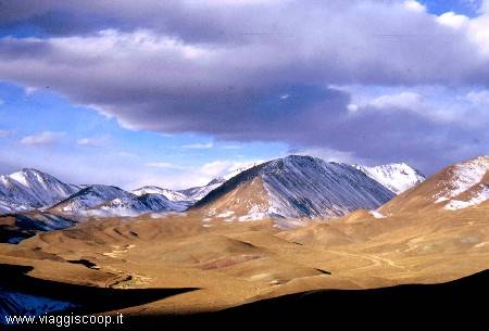
Bolivia, the poorest country in South America, offers this all; beautiful landscapes with beautiful colors, desert plateaus 4000 metres above the sea level, surrounded by snowcapped mountains that reach an height of over 6000 meters, lagoons with shades ranging from pink to green to light blue with many pink flamingos and other birds living on their shores. All in an environment where the human presence is almost totally absent. Certainly the benefit of so much beauty is not free from hardships due to the lack of services, night temperatures that can fall to 20ºC below zero and early wakings in order to admire the colors of dawn. The rising of the sun, give color nuances comparable to those that an artist can paint on canvases. But Bolivia is not only nature: beyond the city, on both mountains and various plateaus extension, lives a wonderful Andean population made of people that knows how to live with very little but is also very proud of its origins and traditions. In the first half of '500 the Spanish "conquistadores", with the Holy Cross in one hand and the sword in the other, reduced the ancient inhabitants (the Inca) to a threaten condition by the imposition of their laws, customs and religion. The Andean nation had to submit to the impositions of Spaniards but, despite that, did not forget its traditions and its religion that are still alive to the present day. This population doesn't recognize conflict between deep Christian faith and devotion to the ancient gods: the Sun god (also known as Inti), the moon goddess and, first of all the mother earth, known as Pachamama. Even today this people use to ask forgiveness to Pachamama before conducting an action that could, in some way, cause disorders or is for some reason deemed offensive, such as entering an ancient Inca site. To be forgotten they offer her what they consider to be the most welcomed gifts: coca extract, alcohol some animal blood, particularly llamas. In many markets of towns and villages can be found, for sale on stalls, mummified llama foetuses : they become appreciated gifts to Pachamama, even after being wrapped in a silk fabric along with other gifts, and being buried under the foundations of new houses in construction. In their churches there are, like from us, many paintings and frescoes that represent sacred figures, but there are also many images of sun and moon, like witnesses of faith.
Although the entire plateau is characterized by beautiful landscapes; it is the southwestern of plateau, the most remote part of the country, which gives the most beautiful and breathtaking visions, with shades of color continuously varying. This region is crossed by few tracks, almost devoid of trees, sparsely populated and subject to sudden climatic changes. But it can be like paradise for those travellers looking for unusual and fascinating places.
After a long flight from Italy, with stops in Chicago and Miami, we land in the morning of August 3rd, 2004, at local 6:00am (noon in Italy), in La Paz airport. The 4100 meters of altitude are felt, and the whole group accuses light dizziness and nausea. From the plateau on which the airport is placed, we can admire the city landscape. La Paz, the highest capital of the world, is perched on the bottom, on the slopes of a canyon 5 kms wide and dominated by both the Illimani massives and the Huayana Potosì. The city transmits an unforgettable image to those that admire it from above. In front of our hotel (which is located in the lower part of the city at about 3600 meters) the situation slightly improves, and only an annoying headache, that will accompany us during our first days in Bolivia, remains . If we add the fatigue accumulated after over 30 hours of travel, and the sleepless night spent in flight, that's why we spent the whole morning sleeping. Only in the evening, sat in a restaurant, in front of a big steak accompanied by chips, we feel better. The price? Less than 3 euros each! Really incredible when compared to our usual prices. The first goal of our journey is the Titicaca lake, placed on the border with Peru. Once arrived in the town of Copacabana, we start a 5 hours trek, in order to reach the lake shore. After a continuous up and down between the eucalyptus trees, we arrive at Yampupata where, with a boat, we'll reach Isla del Sol. During the journey, in a stretch of the trail that winds on a beautiful stone pavement, we meet a reproduction of the Lourdes Grotto that deserves a visit. This place is destination of local religious pilgrimages. Upon reaching the island our physical endurance, already put to the test by 5 hours of walk at almost 4000 meters of altitude, suffers another hit facing the "Inca Steps" that, from 3840 metres of height on the lake shores, leads to an height of about 4000 metres, in the village of Yumani. We stop at about halfway of the staircase to satisfy our thirst at the "Inca Fountain" (a very fresh gush of water that flows from the mountain to enter into three channels made of stone) then, heedless of fatigue, we are walking again towards the village, located on top of the island, that we reach when the sun is already gone, led only by the few light coming out from our lamps. The "Trucia" (trout) of Titicaca lake eaten for dinner is, probably, the "right reward" for this long and tiring day. Second day of trekking: Today we move across the Isla del Sol heading to the north. Fortunately, the stage is less demanding than its predecessor. On the island there are no vehicles and we move only on foot or by boat. This particulars, related to the fantastic landscapes you can admire from the island, make the walk of today particularly pleasant and not tiring at all. On the upper side of island's northern headland lies the site of Inca Chincana, the most spectacular complex of ruins placed in the island. After having visited it, paying particular attention to its more important structure, the "Palacio del Inca", we match the descent to the lake where, with the help of a boat, we return to Copacabana. The weather is very beautiful and the sky is painted of intense blue, without the shadow of any cloud. The sun is reflected by the dark waters of the lake. It seems to be almost at 4000 meters but in a warm day of spring, being on the seashore. Only after having touched the cold waters of the Lake instantly disappears the temptation to make a dip. Today we are less tired than yesterday, so our evening in Copacabana lasts until after 1:00 around a bottle of Pisco.
After a morning devoted to visit the lake town, at 13:00 with a bus, we come back to La Paz from where, at 18:30, is scheduled our departure with a bus that will lead us, after a long night of travel (12 hours) to Sucre, the second capital of Bolivia. The town is located into a valley at 2790 meters of height, surrounded by low mountains. Like all South American cities, Sucre included, is full of markets characterized by live colors and scents of spices, where you can find every kind of goods. And it's at the visit of its covered market that we devote our first morning in Sucre. Around the city there is a paleontological site, located in the Fancesa quarry of cement. The visit of this place requires our afternoon. This is a vertical wall that raised because of many tectonic movements caused by the drift of continents. On this wall a large number of footprints is impressed, left about 60 million of years ago by several species of dinosaurs. At 65 kms from Sucre there is the town of Bittern where, on Sunday, is held a colourful marketplace where you can buy beautiful handicrafts. So, on Sunday morning, we take a bus to run for two hours in a very dusty road that leads us to that village. The goods, characterized by live colors, are exposed in many stalls arranged around the square, thus giving it a festive and cheerful appearance. Once came back to Sucre in the afternoon, at 18 we start to Potosì where we arrive at 21:00. Potosì, the city that with its 4090 meters of altitude is the highest in the world, traces its history during the silver extraction period. It was founded in 1545, following the discovery of silver-rich rocks on the Cerro Rico, the mountain that dominates the landscape. The veins proved to be so rich that its mines briefly became the most productive in the world. The actual Potosì is a testimony of what was a great colonial city. It's to the visit of its mines that we dedicated the morning of our arrival in the city. The excursion to Potosì mine must necessarily start with a visit to the market, where miners made supplies of those genres considered primary for the mine works: coca leaves to relieve from fatigue, cigarettes and dynamite... Not to forget the alcohol (96% pure) to offer to Mother Earth, Pachamama, to apologize for the offence made by digging in its bowels. This visit may be one of the most memorable experiences liveable in Bolivia, because it allows to closely observe the original working conditions that would have already been deemed inhumane in the Middle Ages. The interior of the mine presents low ceiling tunnels and muddy passages. Yet to mention the atmosphere with high percentages of harmful gases, silica dust and acetylene vapours: in essence it seems to have being dropped into the bowels of hell. The most interesting thing to do is to talk with miners who, in exchange for small gifts, will tell you their witnesses about the difficult work they done. Around Potosì there are Tarapaya sources from which flow hot spring waters rich of curative properties... What better opportunity to remove the dust accumulated into mines, if not doing a swim in one of the many pools that surround this place and are fed by springs? The outside temperature, despite the altitude, is pleasant and calls to dive in warm water. Then, after a quick shower made at the hotel where we are, we reach them and we are finally able to join and to be pleased to bathe in their waters. Another goal not to be missed in Potosì is a visit to the "Real Casa de la Moneda", the ancient royal reserve, now turned into one of the most beautiful museums in Bolivia. Thus, waiting to move to Tupiza, on the morning of August 10th we visited it. The palace (really huge) was built between 1573 and 1773 in order to produce currency directly at the origin of the precious metal. In the museum are kept many treasures of historical value, including the first locomotive that travelled across Bolivian territory. Underground is stored the manual equipment once used to produce coins, incredibly still in working conditions. In many rooms there are several boards that put on display interesting ancient coins. With a bus, at 12:30, we start for Tupiza. 7 hours of almost entirely dirt road, very dusty but with a wonderful overview. Along the way we encounter few small isolated villages. Many poultry, including chickens and small black pigs, roam free around these villages; I think that, along with the few fruits that this barren land can give, are the only source of support for the inhabitants of these countries. At our arrival in Tupiza, at 19:30, a light rain welcomes us. Tupiza, 2950 meters high, is surrounded by the Cordillera de Chicas rugged hills and is probably one of the most spectacular cities of Bolivia. Tupiza's surrounding scenarios are fascinating: multicolored rocks, hills, mountains and canyons that recall the old west. Our visit, made following off-road paths and walking a bit, begins from "Puerta del Diablo", a valley characterized by red rocks surrounded by enormous cactus. We continued then with the "Los Machos Valley" with impressive formations eroded by weather, that recall the most famous "Fireplaces of Fate" (in Turkey), and with the "Duento Canyon" that offers an excellent scenario made of beautiful rock formations and deep crevasses covered by cactus that stand out against reddish hills. Yet to quote the "Toroyoj Valley" characterized by spectacular red rocks, the Palquiza village with his beautiful church reminiscent of those seen in films shot in western Mexico. The most spectacular landscape, however, is the one we admired from the top of "El Sillar" (literally The Saddle), located at 3600 meters of height, 15 kms far from Tupiza. It's better to come on the spot at sunset, really the best hours to go there. From this point can be enjoyed a splendid view of its geological formations, jagged amphitheatres dug in the side of the mountain, eroded and shaped like spires that, once illuminated by the light of dusk, offer a breathtaking view. In the days that remain to be spent in Tupiza we wanted to try the thrill of reaching a place called "Entre Rios" with an horseback excursion. This experience can be traumatic for novices like me. Infact, on the way back, my colt suddenly decided to proceed faster, and galloped for a few hundred meters without any possibility for me to stop it. Finally the horse went calm and, throughout the remaining path (luckily), the episode did not repeat.
On August 13rd began the most interesting part of our journey: the visit to the Bolivian plateau with its lagoons and salares. The first goal was the small village of "Quetena Chico", located near the Uturunco Volcano (6020 m), a small settlement that still survives thanks to alluvial gold extraction along the Rio Quetena banks, where searchers dig deep holes and then manually wash the material, separating the golden sand from the real gold; really an hard work even badly paid. Crossing the same stretch of road followed two days ago, we pass again near the El Sillar spires. The road continues to climb, reaching quickly over 4000 meters of altitude. We cross this dusty tracks focusing on this truly spectacular landscape until we reach the small village of San Pablo de Lipez, one of the few plateau towns located near the ghost town of St. Anthony, created by the Spanish and subsequently abandoned. During the trip we make our first meetings with the many llamas, alpacas and vicunas living in these areas, probably the most savage animals of the whole Bolivia. This high and desolate desertic region probably has got one of the world's worst natural conditions, and it is, maybe, the last refuge for many of these animals. The nature that surrounds us is characterized by a rugged beauty, especially on the Laguna Morecon surroundings (it is the first of many lagoons that we met on this plateau). At 19:30, when the dark already dropped, we arrived in the village. Our Spartan accommodation in an icy building, deprived of lighting and heating, is not enough to bring down the morale of the group that remains resolutely high. In order to wipe away the cold we finish dinner by candlelight and with the wind jacket, drinking warm "mulled wine" or, as the locals call it "vino caliente." We woke up early, to start again at 5:00 in order to admire the sunrise on Celeste (light blue) Lagoon, a destination maybe mainly unknown to ordinary travellers but that certainly deserves a visit, especially if happens to be on its shores before dawn. We try to mitigate the disturbing cold on the moments before dawn lighting different bonfires on the lagoon banks. At dawn its water increasingly paint with colors that are gradually warmer, and the reflection of mountains form a landscape of unreal beauty: the faced hardships are now all widely rewarded! We return to the "Quetena Chico" village to both enjoy an abundant breakfast and recover baggage, needed for the next travel to San Pedro de Atacama, Chile. The landscapes met during our trip are always beautiful, as we cross an area rich of active volcanoes, geysers, hot springs, lagoons and salted deserts. The soil is full of minerals that mixing up produce unthinkable colors, creating then spectacular lagoons. Many are the lagoons and salares that we meet, including: Laguna Hedionda Sur, Laguna Collpa (with its borax formations), salar de Chalbri, Laguna Polchis (also with borax formations) and Laguna Verde, characterized by shades of unthinkable color that vary from green to blue, located in an exposed area and always wiped by a cold wind, behind which stands the immense cone of Licancabur volcano (5960 metres). The last lagoon we meet before the Chilean border is Laguna Blanca. Just here, during a stop for lunch, begins to snow. In short time the land is held by a slight layer of snow and the landscape, already beautiful, took a particular fascination. Once crossed the border with Chile we quickly reach the San Pedro de Atacama village.we arrive too early, so we take advantage to visit the Moon Valley. This valley, located near San Pedro de Atacama, is famous for its looking that recalls the lunar surface. The best time to visit it is certainly at the time of sunset, when the rocky structures are coloured with intense hues ranging from yellow to red. Today, August 15th, at 4:00 we wake early to participate to an excursion to "El Tatio" geysers, 4300 meters high above sea level. The very early departure is justified, since our guide explained that geysers erupt only in the early morning. Infact, because of the action of strong winds that grow up during the day, vapours are dispersed. We arrive at the huge "caldera" of El Tatio around 6:00 and from afar we begin to see a lot of thin bluish smoke trails: geysers, here we are! Getting nearby seems to penetrate inside Dante's Inferno: columns of steam rise from cracks self-opened on the rock, where water noisily bubbles. It's quite surprising to be even in an environment where water coexists in its three stages: solid, liquid and gas. Fresh snow fell during the night makes the landscape even more attractive. After having left El Tatio area we head towards San Pedro de Atacama outskirts. The first destination is the village of Caspana at 3264 meters of altitude. Originally prehispanic, this village is characterized by its stone built architecture and its particular roofs. Currently its 400 inhabitants live with the production of flowers and vegetables, then sold in the province capital, Calama. We continue with a visit to Chiu Chiu village (2400 meters) with its characteristic church. This church, built in 1612, has the plant shaped like a Latin cross. Its walls have a thickness of 1,2 metres and the roof has a cactus-wood support structure. The main front has two towers (made of stone and built in 1965 during a restoration opera) instead of the original that fell in the nineteenth century. The church is placed inside a sort of wall fence which also contains ancient tombs. Today, August 16th, in the afternoon we should return to Bolivia, but we receive the bad news that the border is now closed for snow. If it is really not agibile, we should remain one more day in Chile. In the morning we visit the Salar de Atacama where is located the Laguna Chaxa. The Salar, placed at 2500 meters of height, it has an area of about 4000 km² and is the largest of Chile. On its surface you can see a crust of salt, caused by the buildup of crystals that form as a result of water evaporation. The lake microenvironment of the Salar, especially in the area of its lagoon, generates microorganisms that attract many flamingos; in the climate and in the silence of the Salar, they find an ideal environment for nesting. However the step is still closed, we hope that tomorrow the road will be opened again.
Finally at 13:00 of August 17th the road is opened. Once passed customs formalities we are on travel again to reach, at 14:15, the Bolivian plateau where we expect to find both our two cars and their drivers. We begin the second part of our visit of this place: our first goal is the Laguna Colorada. The weather is beautiful, with an intense blue sky without clouds, even if the air is cold and a cold wind blows. We are crossing again a stretch of the trail already made few days earlier. We see again both Laguna Blanca and Laguna Verde in a nice sunny day, while the previous visit took place under a light snowfall. A quick visit to the Apaceta geysers, at over 4800 meters of height, and we continue through the Laguna Colorada where we arrive at sunset. The lagoon, with its fire red colored water, is 4278 meters high and covers an area of about 60 km² but reaches a depth of only 80 cms. The typical lively red colour is caused by algae and plankton present in its waters rich of minerals. Here you can observe many flamingos, which probably have chosen this area because they felt it would be the best for their reproduction, despite the cold temperatures that, at night, may fall 20ºC below zero. From the place where we stop the lagoon seems very close to us, just only two steps far. Thus, despite the incoming evening and the increasing cold we decide to reach its banks on foot, because we have only to cross a long plateau covered of stones. But the lagoon is further than it seemed before: after about ½ hour of walk, worried from the incoming darkness, we took the decision to come back and delay the visit to the next days. The morning after we visited the village of San Juan del Rosario. Before leaving this town we dedicate few hours to visit the lagoon which, illuminated by the morning light, shows itself in all its splendor. The many flamingos that live on its shores don't seem to be disturbed by our presence and continue to seek food in lagoon's low water. The landscape is very suggestive and the beauty of this place helps us to challenge the cold and icy wind that continues to blow on us. This is surely the most beautiful landscape I observed up to now. We continue the journey with the passage through the desert of Siloli, 18 kms at north of Laguna Colorada. Here we meet various strange rock formations, of which the best known is certainly the "Arbol de Piedra", literally Stone Tree. This conformation, which resembles a real tree, is a rock eroded by the wind that stands high in the desolate expanse of the desert. We pass by numerous beautiful lagoons: Laguna Honda, Laguna Chota, Laguna Hedionda North (4186 meters, plenty of flamingos) and Laguna Hemp (4151 meters, a huge salt lake surrounded by high mountains). During a stop for lunch begins to snow. At 8:30, August 19th, we are going to the town of Uyuni with its famous Salar, a boundless expanse of salt with several "islands" that seem to tick from the sea. The weather doesn't promise anything good but, despite the light rain that accompanies us, the landscape doesn't lose its wild charm. The Salar de Uyuni, with its 12106 km² surface, is the largest salt lake in Bolivia. Once this part of plateau was completely submerged by water. In the limestone rocks of what was supposed to be a lake many coral fossils can be seen. The salt deposits are the resultof the erosion of minerals coming from the surrounding mountains. Today, the Salar has become a salt extraction and processing zone that has its epicentre in the town of Colchani, located 20 kms far from Uyuni. When the surface of the Salar dries the salt transforms the landscape in a giant blinding white expanse, instead, when these plains contain water, they form a perfectly reflecting mirror that completely hides the horizon. Passing through these plains gives a supernatural sensation. It really seems to be suspended in the air. Among the many "islands" that arise from this white salt expanse, the most famous is certainly the charming Isla del Pescado. It is thought that his name derives from its shape (reminiscent of a fish) reflected in the Salar. The whole island is covered by cactus and surrounded by a "sea" of hexagonal shaped white tiles of salt. Once parked our off-roads we climb the hill until its top, from which we can enjoy a beautiful view on the boundless expanse of salt that losts all around in the haze. Only the light rain that falls partially ruins the fascinating landscape. Continuing with the journey we meet the Uyuni Salt Hotel. This unique hotel is entirely built with salt blocks and is located about 20 kms far from Colchani. As hotel it is nothing special, but its position inside the Salar exerts a certain fascination about visitors. An interesting and unusual thing to highlight is the cartel placed immediately after the entry, inviting visitors to buy something at the bar before starting an eventual visit to the construction. Entered the town of Uyuni, before visiting hotel, we went to the "graveyard of trains", the second biggest attraction of the place after the Salar. It is a huge pile of abandoned old steam locomotives and wagons, placed 1 km far from the village. Interesting the ironic writings that can be seen on some of the old locomotives, in particular one that calls for the urgent intervention of a good mechanic. The town of Uyuni offers virtually no more than intense cold and some roads affected by cold air currents.
On August 20th we return to the Salar, this time with a beautiful sun accompanying us. We retrace the route already done during the first day, finally reaching an island on which stands the small village of Coqueza, dominated by the Tunupa volcano (5400 m). In front of the village, many sources form a strip of water that separates the soil from the Salar. This water flows in every season, while the Salar dissolves only in the rainy season and, because of this, is possible to arrive in Coqueza on a road built on an artificial embankment, just wide enough to permit the passage of a car, limited with some stones and partly submerged. On the shore of Salar graze many llamas and on the water, not far from us, lie a nice colony of pink flamingos and a pair of large Andean flamingos. The hostel where we sleep has walls made of raw earth bricks, mud plastered and painted white. The ceiling is made with canvas sacks sewn together, nailed to the walls and painted with the same white tempera. There's a window, however, sufficient to shelter us from the wind. On the slopes of Tunupa Volcano are kept, inside a cave, the mummified bodies of thousand years old men, belonging to Chipaya population. The funeral rites recently celebrated and the deals recently deposed behind the poor graves, make us able to understand how close, even today, is the link that the Andean people feel with their ancestors. Unfortunately, it is comprehensible that the isolation of these places contributed to the gradual impoverishment of the tombs by thiefs and private collectors. After this visit, some of us decided to climb the hill placed under the volcano. The climb to the over 4500 metres of the hill takes place on an easy path, but the altitude is felt. The beautiful landscape on both the Coqueza village and the Salar repays the effort made; it's a sin not to have the time to try to reach its top, but we must come back from the slopes of the volcano before the darkness arrives. Tomorrow we will definitively leave the Salar and the plateau to go to Chile again. We celebrated the last night here with a good grilled meat based dinner. The next day we are crossing the Salar again, this time in direction of the Chilean border. The landscape on the plateau is always fascinating; we pass Coipasa Salar (3786 meters), much smaller and less spectacular than Uyuni Salar. At 16:00 we arrive at the border with Chile where, done the customs practices, we expect to find two buses to reach the Colchane village, immediately after the border. Colchane consists of a few houses, and there is virtually nothing to see in it. Only a major military centre and the hostel where we book, not a shop or a bar. The only positive note is the good dinner (in the hostel), based on soup, llama steak and potatoes puree. At 8:30, August 22nd, with any regret we leave Colchane to head towards the Isluga Park with its volcanoes, abandoned villages and wide valleys surrounded by mountains exceeding 5000 meters. Even if not spectacular as those on the Bolivian plateau, landscapes are however fascinating. Leaving the park we meet a salar with small puddles of hot water: the Piocheres Salar. In these natural pools where the water reaches 60°C it is possible to swim. The outside temperature is cold and doesn't invite to undress, so we enter into only with our feet. On the opposite side of the salar there is the Laguna Cerro Vinto, packed with flamingos. After the many lagoons encountered in the past few days we are not so much interested, and the visit is very fast. At 19:00 we arrive at our destination: the town of Putre. Today, August 23rd, is the last day of our trip in Chile, tomorrow we'll go back to La Paz. We visit another Chilean park, at Lauca, on the border with Bolivia. The park has an area of 137.883 hectares and is located at an height ranging from 3200 to 6342 meters above sea level; in its surface is possible to meet many vicunas. During the night the snow fallen, bleaching the landscape and making it even more fascinating. The visit of the park continues with the Cotacotani lagoon (4400 meters of altitude). This lagoon was formed after an eruption, accompanied by a strong outflow of lava coming from the Parinacota volcano. It is composed of a large lake where there are numerous volcanic islets. The road that passes through this places was built about 200 meters further up the lagoon; in order to observe it closely we descend on its shores. But begins to snow and it's cold enough. In the opposite side of the lagoon we can see the imposing shape of Parinacota volcano, partly visible because immersed in clouds. If the descent on the shore of the lagoon was smooth, not so is getting back to where our bus is expected to be: we are at over 4000 meters of altitude, we climb it slowly breathing with difficult. We continue until the border with Bolivia, on the shores of Chungarà Lake. The weather remained rainy and sometimes snowy. On the way back to Putre we visit the small Parinacota village, namesake of the great volcano which lies within its vicinity. Our journey draws to the close, we have to return to Bolivia, at La Paz, where we'll stay for two days before embark to come back in Italy. We employed the first day for sightseeing, but we can not go around because there's the strike of all public transports, including taxis. We conclude our vacation in Bolivia with an emotional downhill mountain biking. With a minibus, carrying the bikes, we reach La Cumbre, a pass at 4700 meters of height across the Cordillera. From here, we must proceed for 70 kms (of which only the first 20 are in tarmac) to reach the village of Coroico (at about 1200 meters), with a descent of about 3500 metres. The road connecting La Paz to Coroico is officially named "The most dangerous of the world" for the large number of fatal accidents that occur there. Despite this, the descent by bicycle from La Cumbre to Coroico is one of the most popular in Bolivia, because it allows you to combine the pleasure of a long downhill race with the arrival in a beautiful location. The "vertical" landscape which is visible from the road that drops to Coroico is a real treat for those who travels by bicycle, here you can stay seated without cycling letting the gravity do the work! Along this route you can admire an incredibly varied landscape while making a spectacular drop in a scenario completely different from that seen on the other side of the Cordillera; fascinating but spoiled highlands are replaced by almost vertical walls where lush vegetation grows. During the return trip, a break of almost a day in New York allows us to visit, albeit summarily, the island of Manhattan and "ground zero", the place where stood the two demolished twin towers from 11th September 2001.
|
|